Creating Risk Detection Solutions Using Satellite Imagery
TreeSight is our advanced solution for monitoring power lines using Earth Observation (EO) data. It integrates vegetation management into power infrastructure management without on-field interventions. Ideal for energy companies and utilities, TreeSight enhances safety, mitigates risks, and improves efficiency.
01. INTRO
Creating Risk Detection Solutions Using Satellite Imagery
At Cactus, we set out to find a solution to accelerate and improve the process of monitoring Electric power transmission lines and complement the current methods to monitor these based on helicopter inspections through LiDAR. By utilizing satellite imagery from Pléiades and applying advance AI, we developed a solution that mitigates the dangers associated with traditional methods, making the process safer, more efficient and less costly.
02. CHALLENGE
Remote Decision-Making for Infrastructure Monitoring
The challenge was to create a platform that could process the data in real-time, providing actionable insights on potential hazards and enabling remote decision-making, allowing infrastructure managers and maintenance teams to detect issues, prioritize corrective and preventive actions, and at the same time ensure safety.
03. SOLUTION
Creating a Height Calculation Algorithm
The solution we have designed consists on several software modules:
- Satellite data collector: This module retrieves high-resolution satellite imagery from Pléiades. The imagery is preprocessed using orthorectification, ensuring accurate distance and spatial alignment by correcting for terrain distortions and satellite angles. This prepares the data for further analysis, ensuring that the vegetation and infrastructure can be accurately mapped and monitored.
- A GIS dashboard: The GIS dashboard is a user-friendly interface that displays an interactive map highlighting electrical infrastructure. Users can click on specific zones to initiate the vegetation analysis process for that area.
- NDVI Filter: We began by applying a Normalized Difference Vegetation Index (NDVI) filter to spot vegetation near the electrical infrastructure, ensuring that only relevant elements were processed.
- CNN: A Convolutional Neural Network (CNN) was trained to detect vegetation and its shadow, enabling the system to identify both of them in satellite imagery with high accuracy.
- Shadow Director Vector Calculator: We developed a shadow vector calculator to analyze the direction and length of shadows, allowing us to infer the relative position and height of the vegetation.
- YOLO Model: A YOLO (You Only Look Once) model was integrated to detect each tree’s position. This creates instances of the segmentation, a similar result as if panoptic segmentation models had been used.
- Height Estimator: Finally, we built a height estimator that combined the data from the CNN, YOLO model and shadow vector calculations to determine the precise height of vegetation, ensuring accurate remote monitoring.
The product is a Geospatial software platform that allows for real-time height calculations of vegetation, providing infrastructure managers with critical insights to improve safety and efficiency.
04. RESULT
Enhancing Safety through Data-Driven Monitoring Solutions
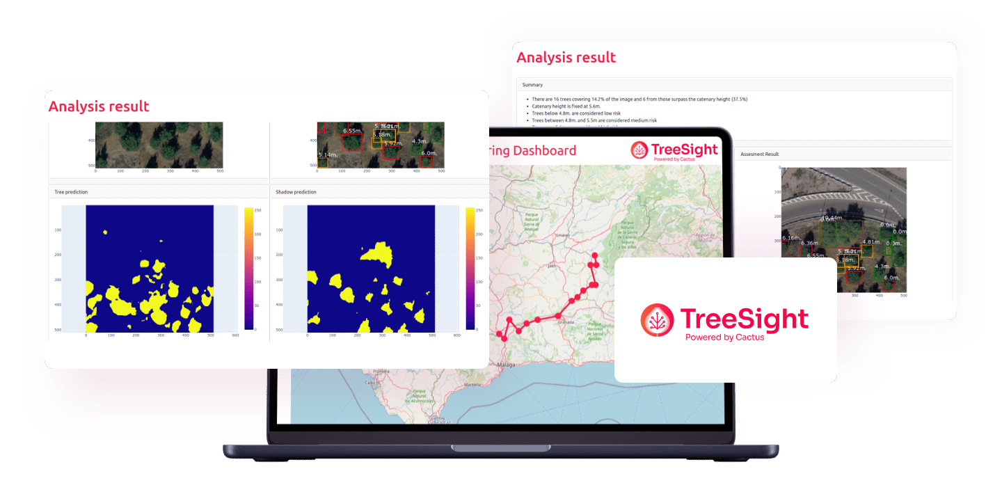
The solution enables electricity infrastructure companies to perform monitoring, optimization, and enhancement of electrical infrastructure safety. With precise, real-time data processing, it is now possible to detect potential hazards and address them proactively, minimizing risks. This advanced, data-driven monitoring approach ensures the reliability and security of critical systems, significantly improving overall infrastructure safety.

CONCLUSION
Innovating to Ensure Safety
At Cactus, we are committed to finding solutions that utilize data to improve people’s conditions. Our goal is to streamline processes, enable new applications and develop solutions cost-effective and safer, by enabling remote monitoring to replace much of the traditional methods.